General Information
- Site Rating: P2+ or P1 under direct instructor supervision, H3, M2
- Use Parameters: Wind not exceeding 12 MPH for PG and Mini Wings, 15 MPH for HG. Wind direction N, NW, W, SW, S
- Site Support: Site is paid for, managed and maintained by the Northwest Paragliding Club. Washington State DNR (Department of Natural Resources) expects that all pilots flying Tiger are NWPC members. Visiting Pilot Memberships are available.
- USHPA Membership required for all pilots flying Tiger Mountain
- Best months to fly: April - August, but flyable all year.
- Best times to fly: Given an 8:30 PM sunset, thermals are best from 1-4pm. Glass offs often run from 5 to 8:30 pm.
- Pilots can hike up or use community shuttles. There is no public drive-up access to the site.
- Use extreme caution when East winds are present or possible.
Beware!
• Ideal launching conditions at Tiger are in winds not exceeding 12-15mph with recommend top winds of 12mph.
• Launching in East winds is not recommended due to the LZ and most of the mountain being in the lee.
• The LZ can be very active in mid summer. Fly actively until landed.
• West winds can cause issues in the landing zone where the wind can switch between North and South due to the presence of Squak Mtn opposite Tiger Mtn.
• The valley between Squak Mtn and Tiger Mtn acts as a venturi in stronger winds.
• Student Pilots generally are recognized by streamers attached to their wings. Give them space.
• Mini wings and hang gliders sometimes fly at Tiger! The characteristics of each wing are different, and pilots should be aware of their needs. Hang-gliders need to take a straight-in approach to land, so wings doing S turns on approach is difficult for them. Mini-wings need a low, tight turn on approach.
North Launch
- Elevation: 1,830'. GPS Coordinates: 47°29'58"N 122°0'30"W
- North Launch Weather Station Updated Every 5min. Click Here
- LZ Weather Station Updated Every 1min. Click Here
- Glide ratio to LZ : 2:1
- Wind Direction: Ideal N through NW. West through NNE OK
- Wind Strength: Min: 0, Ideal: 7, Max: 12 MPH (Max 15 MPH for HG)


South Launch
- Elevation: 1,680'. GPS Coordinates: 47°29'48"N 122°0'38"W
- When launching from south, pilots must navigate out and around to the right to clear the southwest arm of Tiger in order to then fly north to the LZ.
- Glide ratio to LZ : 3:1
- Wind Direction: Ideal SSE to SW East winds in excess of 2 kts create hazardous conditions
- Wind Strength: Min: 0, Ideal: 7, Max: 12 MPH (Max 15 MPH for HG)
Tiger LZ
- Elevation: 180'. GPS Coordinates: 47°30'01.6"N 122°01'19.1"W
Site Requirements
- Helmets are required.
- Conditions at Tiger Mountain can be unpredictable and change rapidly. A site briefing is strongly advised. A NWPC visiting pilot membership includes a site briefing.
- USHPA Membership required for all pilots flying Tiger Mountain.
- Pilots should follow all USHPA rules when flying at Tiger Mountain, including utilization of proper safety equipment (reserve parachute, radio, boots, back protection, speed bar, etc).
- All pilots are required to follow USHPA right-of-way rules and to maintain adequate separation from other pilots.
- Motorized paragliders and motorized hang gliders are not permitted in the LZ.
- The minimum rating for hang pilots is H2 with instructor or H3 without.
- Use of the upper north launch is prohibited when horses are present.
- Pilots must follow FAA rules which include VFR separation from clouds. For more information, see Aeronautical Information Manual at www.faa.gov.
Description
Tiger Mountain is a beautiful place to fly with majestic views of Mt. Rainier, the Cascade and Olympic mountain ranges, along with Puget Sound and the lakes and cities of the greater metropolitan area. The views, along with the easy access to launch, and great consistent flying have made Tiger Mountain one of the most popular flying sites in the United States.
Extensive work has been done at Tiger by the paragliding community, Northwest paragliding club and Team Chirico over the last 15 years. Trees have been cleared (in cooperation with DNR), grass planted, bathrooms installed, and more artificial turf laid on north launch to support an upper and lower launch, as well as a new 80' weather tower providing conditions every 5 minutes. The club also worked with DNR to build an access road for the shuttle service which eliminates a 300 yd hike through the woods to transfer into a 2nd shuttle, instead allowing the shuttle to drive from the LZ directly to launch. The city of Issaquah officially lists paragliding at Tiger Mountain as a community treasure.
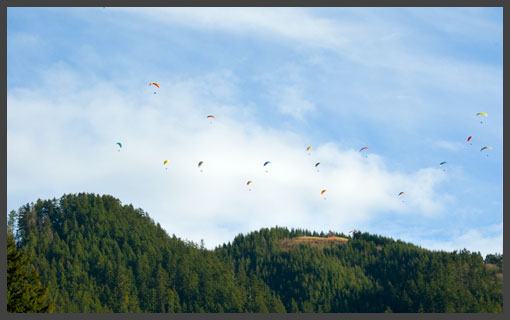
Tiger is flyable with winds from the south, west and, preferably, the north. During peak season, Tiger Mt. provides prolific lift for beginner pilots to enjoy hour long flights. More advanced pilots will find ample cross country potential at Tiger. Flights from Tiger have gone as far North as the Canadian border, South past Mt. Rainier, and East through Snoqualmie pass into eastern Washington. A soaring flight over launch provides spectacular views of Mt. Rainier to the south, Mt. Si, to the east, Mt Baker and Lake Sammamish to the north, and Seattle’s skyline to the west. It’s beautiful. With extended daylight hours in the summer the last flights typically land around 9pm. If timed correctly one can launch, catch the glass off, and watch the sunset from the air. Complimenting the great flying are the many pilots who hang out at Tiger. A quick 30 minute drive from downtown Seattle make’s it possible to catch a quick flight after work, or even as an extended lunch flight. Local pilots often gather for good flying, post flying BBQs, and good company. The popularity of the site can make for somewhat crowded conditions on launch and in the air.
Site Protocol
Standard ridge rules apply at Tiger:
- Pilot with the ridge on the right has the right of way.
- First one in the thermal determines direction.
- Gliders on top yield to gliders below.
-
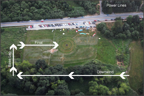
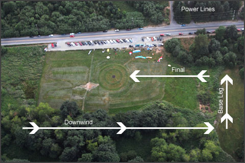
The Tiger LZ uses a standard aircraft approach of downwind to base leg to final. For safety, the downwind approach should be over the trees on the east side of the LZ. The west side of the LZ contains power lines, light poles and can distract traffic on the road.
Tiger North Launch Top Landing Protocol
- Top landing may only be attempted when the area to be landed in is clear of pilots and spectators.
- Top landing must never interfere with launching pilots. If a pilot is set up to launch, you must stay completely clear of their launching operation.
- When the launch is busy, top landings should be avoided.
- When the launch is busy, it *may* be acceptable to side land on the west face but only if the landing pilot and wing does not interfere with activity on launch and only if the west face is clear of pilots and spectators.
- Pilots and spectators are not expected to scramble out of the way for top landing pilots.
- Top landing is expressly prohibited when horses are present.
- Top landing pilots must always yield to to launching traffic and people on the launch.
- Top landing pilots must never fly over the heads of pilots or spectators on launch, and especially never fly over a glider ready to be pulled up.
- When students are launching, provide an even larger margin of safety over the above prescribed rules.
North Approach
South Approach
No Landing Zones
Some folks around the Tiger area do not like us landing at their property. The google maps link shows you the no landing zones that the club is currently aware of near the sites that we fly.. please do not land in these area. The Openair text file allows you to load it into xcsoar, xctrack,lk8000 and Oudie if you convert it to cub format using SeeYou software. These areas will then be displayed as restricted airspace at ground level on your flying instruments.
Openair Airspace text file
Google maps no landing zones
Soaring and Airspace
Tiger Mountain is extremely soarable. Most XC pilots work Tiger up to cloudbase, and then, depending on wind direction, fly south to Enumclaw, east towards Mt. Si or north towards Duval. Due to airspace restrictions and the lack of LZs there is very little XC potential to the west. Controlled airspace directly over Tiger Mt. north and south launches is 5,000 and rises to 6,000' about 1/2 way between launches and the Tiger summit. Commercial jets can and do get vectored over Tiger. Do NOT break airspace. Commercial jets are also allowed to fly in below controlled airspace. If you find yourself above 4,000' above Tiger on a North day, keep your eyes open and head on a swivel.
Directions to the LZ
From Seattle take I-90 east to exit #17, Front Street exit in Issaquah. Head south on Front Street. It eventually turns into Issaquah-Hobart Road. After leaving downtown Issaquah, follow for about 2 more miles to where the road widens with a 2-way left turn lane. The LZ parking and grass field will be on your left. Parking is limited so you may find yourself parking on the street. There is also a $5 pay lot on the west side of the street about 50 yards before the LZ. - GPS Coordinates - 47º 30' 01.6"N 122º 01' 19.1"W
Directions to Launch
Hike The Chirico trail is a moderate 1 hour (+/- 20 minutes) hike directly from the LZ to south and north launches. The trail entrance is easily found on the east side of the LZ. The trail is moderately challenging with 1,500’ elevation gain over 2 miles.
Shuttle
Shuttles are currently being organized by the community and the local schools. For communication please use the Telegram channels.